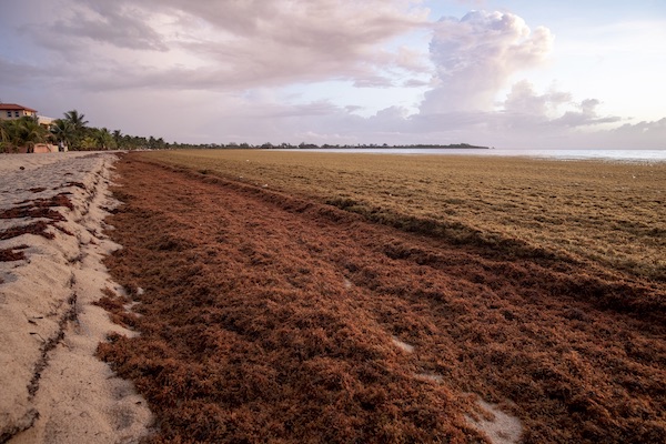
Pelagic Sargassum is a buoyant macroalgae that forms rafts at the ocean surface and serve as a biologically rich habitat for hundreds of diverse marine species. Since 2011, massive blooms of Sargassum have occurred in the tropical Atlantic and swept through the western tropical Atlantic, Caribbean Sea, and Gulf of America. These recurring annual events have caused significant disruptions to coastal communities throughout the region, negatively impacting human health, tourism, fishing, navigation, coastal management operations, and nearshore ecosystems, and representing a challenge to national economies and the achievement of United Nations Sustainable Development Goals (SDGs) in the region.
Objective
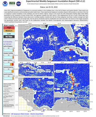
The objective of this session is to present the data sources and analytic techniques that provide information about the spatiotemporal differences in the potential of Sargassum coastal inundation and open ocean areal extension across the Intra-American Seas, and a comprehensive method for assessing its geographic distribution and temporal variation. As a result of this activity, the audience will share insights of the methodologies that can quantify and monitor the potential of Sargassum coastal inundation on a regular and continuous basis throughout the Caribbean Sea region, Gulf of America, and extending to the east coast of Florida and the Bahamas. Several product suites have been created as a strategic response to the need to improve the management of Sargassum influxes in the region (e.g. coordinate clean-up), which have major economic, social, environmental and public health impacts. These products provide assessments of the presence and amount of Sargassum in the vicinity of a coastline in one or more areas of the Intra-American Sea and represent a first stage of available resources to account for the potential of Sargassum presence in the vicinity of coastal areas and to promote informed decision-making, while more sophisticated coastal models are currently being developed and implemented. These platforms thus represent an initial step towards a qualitative approach to support data-driven decision-making and planning. Their data distribution schema enhances interoperability and the use of information by decision managers and a large number of stakeholders requiring digital georeferenced datasets. This action provides a common ground to engage additional stakeholders in other geographic regions affected by Sargassum influxes (e.g. from nations along the coast of West Africa) and diverse backgrounds (e.g. metagenomics, biochemistry, economists), and highlights the need to integrate and coordinate the existing monitoring efforts within a common partnership.
[Read More]