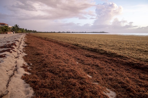
Pelagic Sargassum is a buoyant macroalgae that forms rafts at the ocean surface and serve as a biologically rich habitat for hundreds of diverse marine species. Since 2011, massive blooms of Sargassum have occurred in the tropical Atlantic and swept through the western tropical Atlantic, Caribbean Sea, and Gulf of America. These recurring annual events have caused significant disruptions to coastal communities throughout the region, negatively impacting human health, tourism, fishing, navigation, coastal management operations, and nearshore ecosystems, and representing a challenge to national economies and the achievement of United Nations Sustainable Development Goals (SDGs) in the region.
Objective
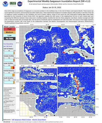
The objective of this session is to present the data sources and analytic techniques that provide information about the spatiotemporal differences in the potential of Sargassum coastal inundation and open ocean areal extension across the Intra-American Seas, and a comprehensive method for assessing its geographic distribution and temporal variation. As a result of this activity, the audience will share insights of the methodologies that can quantify and monitor the potential of Sargassum coastal inundation on a regular and continuous basis throughout the Caribbean Sea region, Gulf of America, and extending to the east coast of Florida and the Bahamas. Several product suites have been created as a strategic response to the need to improve the management of Sargassum influxes in the region (e.g. coordinate clean-up), which have major economic, social, environmental and public health impacts. These products provide assessments of the presence and amount of Sargassum in the vicinity of a coastline in one or more areas of the Intra-American Sea and represent a first stage of available resources to account for the potential of Sargassum presence in the vicinity of coastal areas and to promote informed decision-making, while more sophisticated coastal models are currently being developed and implemented. These platforms thus represent an initial step towards a qualitative approach to support data-driven decision-making and planning. Their data distribution schema enhances interoperability and the use of information by decision managers and a large number of stakeholders requiring digital georeferenced datasets. This action provides a common ground to engage additional stakeholders in other geographic regions affected by Sargassum influxes (e.g. from nations along the coast of West Africa) and diverse backgrounds (e.g. metagenomics, biochemistry, economists), and highlights the need to integrate and coordinate the existing monitoring efforts within a common partnership.

Aproach
The proposed Satellite Activity spans 2 hours and includes a description of the (state-of-the-art) most recent advances, research and developments in the area of monitoring sargassum and sargassum inundation through satellite and/or joint satellite and field observations- through a series of presentations, containing practical examples of data integration and visualization within, for example, an interoperable online environment. This approach, in our view, offers several advantages:
- The speakers bring multiple perspectives and a multidisciplinary approach to the topic.
- It will allow us to respond to key questions related to the regime shift in 2011, which triggered the influx of pelagic Sargassum into the region.
- It highlights the advantage of using satellite sensors to achieve synoptic coverage and provide near-real-time products within operational scenarios. It also displays the benefits of data integration (e.g. citizen science and regional datasets).
- It reveals the importance of having a diverse range of products addressed to multiple audiences, meeting the needs of experts, decision-makers, and the general public. This activity represents an opportunity to elicit new products and services. The participants, presenters, and key stakeholders will represent multiple countries and backgrounds, have diverse socioeconomic and cultural backgrounds, and face common interests and environmental challenges.
Scalability and Replicability
Large influxes of pelagic Sargassum generate significant and highly visible impacts in the environment, economy, and health of the region. These consequences are portrayed in the media and on social networks, including NOAA’s. We plan to use these channels to disseminate the information about the proposed event, including newsletters, outreach and educational activities, and email alerts. We estimate that this Activity will might bring representative key stakeholders, networks and projects to the table, fostering stakeholder identification and partnership development. This Satellite Activity might also serve as a template for addressing similar algae events in other world regions (e.g. China, Australia) and has the potential to be linked to other activities in the fields of oceanography, biochemistry, remote sensing, economic assessment, among many others. Looking into the future, we consider this Satellite Activity has the potential to expand to include long term forecasts, climate variability, growth models, regional/local dynamics, coastal interactions, and public health impacts.
Technical implementation
We plan to use Google Meet to livestream the activity to multiple users. The audience will be able to interact with the invited speakers with time reserved for questions. No registration is required for this Satellite Activity. All the contents will be open to the wider community. The event language is English. Some presentation slides will also be available in Spanish.